Activity Messenger Help Center
Geographic and demographics report
Use Geographic and demographics to see where your participants live, review their ages and genders, and measure how much of your class or booking activity comes from nearby clients. Switch between Participants, Classes by radius and Bookings by radius to answer different questions.
Before you start
The report is available to organization owners and administrators. Accountants and other roles do not have access. Bookings by radius is available when your organization uses bookings.
Radius comparisons use your organization's address as their starting point. Make sure that address is complete. The map's outlier filter also needs an organization location.
Open the report and choose the period
- Open E-Commerce > Reports.
- Select Geographic and demographics from the report menu.
- Select the date range at the top of the page.
- Choose Participants, Classes by radius or Bookings by radius below the map.
- To narrow the class population, use Class tags in the toolbar below the map. Clear this filter when you want to use Bookings by radius.
Classes qualify when at least one of their sessions starts within the selected period. Paid bookings qualify by their booking start date. These dates select the activities to include; they do not create a historical snapshot of addresses or demographics.
Review the Participants view
Participants combines people from the selected classes and bookings. Selecting class tags restricts this view to the matching classes and leaves bookings out.
The summary at the top shows Classes, Bookings and Clients for the report selection. Below the map, review:
- Genders: the number of people for each available gender value.
- Ages: the number of people for each available age. Ages are calculated from the available date of birth when you run the report.
- Unique zip/postal codes: postal codes and the number of people associated with each one. The coverage message shows how many participants have a postal code.
People are identified using their name and linked client account. Someone appearing in several classes or bookings is counted once in the participant population; different named family members can count separately. Missing demographic values mean the gender and age tables may cover fewer people than the Clients total. People without a postal code remain in the overall population but do not appear in this view's postal-code table or on its map.
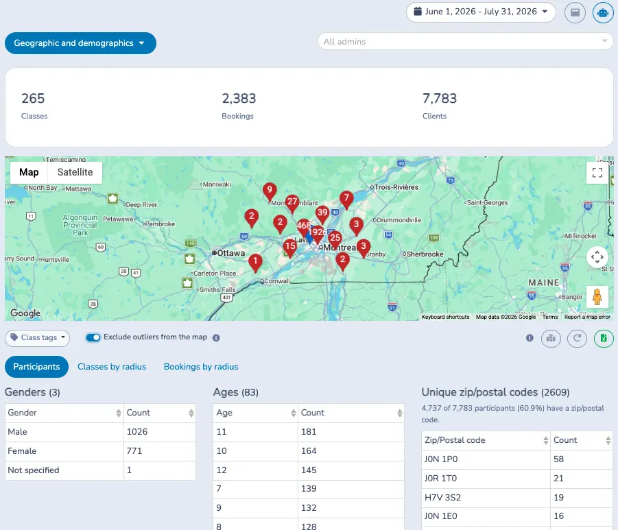
For example, the coverage message in this image says 4,737 of 7,783 participants (60.9%) have a zip/postal code. The map therefore represents the available postal-code data, rather than every person in the report.
Read the map and toolbar
The blue pin marks your organization. Red pins represent postal-code locations or clusters of nearby locations. In Participants, pin labels show how many postal codes are represented; in a radius view, labels count registrations or bookings. Click a cluster to zoom into its locations.
Canadian postal codes are grouped by their first three characters in the Participants map. Locations are approximate; a pin is not an individual street address. Invalid or ambiguous postal-code values can be excluded from the map.
The toolbar below the map contains Class tags, the outlier switch, information icons, a map-fit button, a refresh button and the green Excel button. The muted information icons explain the counting method and controls. The map-fit button fits the visible locations in Participants, or the selected radius in a radius view. Refresh reloads the report and picks up newly resolved locations.
Exclude outliers from the map
Turn on Exclude outliers from the map to hide pins more than 100 km from your organization. This helps keep distant locations from making the map zoom out too far.
The switch changes the map only. It does not remove people, registrations or bookings from totals, tables, percentage bars or Excel exports. It uses straight-line distance, so a location in another province can remain visible when it is within 100 km.
The 100 km cutoff is separate from Local radius (km). If you choose a local radius greater than 100 km and want to see all locations within it, turn off the outlier switch.
Set a local radius
- Choose Classes by radius or Bookings by radius.
- Enter a whole number from 1 to 500 in Local radius (km). The default is 5 km.
- Select Apply.
- Read the totals, percentage bars and postal-code detail below the controls.
The distance is measured in a straight line from the organization's address to an approximate postal-code location. A location exactly on the selected radius is included in Local.
| Area | Meaning |
|---|---|
| Local | The location is within the selected radius, including its boundary. |
| Outside radius | The location is farther than the selected radius. |
| Unknown | An address or postal code is missing, unsupported, unresolved, or cannot be placed reliably on either side of the radius. |
These areas help compare your service area. They do not establish municipal residency or driving distance.
Compare Classes by radius
Classes by radius includes participants registered in classes with a session in the selected period. Class tags applies to this view. Bookings are excluded.
The two bars measure different things:
- Unique class participants: each person counts once across the selected classes.
- Registrations: each class registration counts once, regardless of how many sessions the class has in the period.
For example, one person registered in three qualifying classes contributes 1 unique participant and 3 registrations. A class with several sessions does not multiply that registration by its number of sessions.
The Class registrations by postal code table shows unique participants, registrations, registration share, approximate distance and area. Compare the two bars to see whether nearby participants account for a larger share of registrations than their share of people.
Compare Bookings by radius
Clear Class tags, then choose Bookings by radius. This view includes paid bookings starting in the selected period.
- Unique bookers: unique invoice account owners who booked during the period. Repeated bookings by the same owner do not increase this count.
- Bookings: each paid booking counts once. A shared booking is attributed to the account owner on its first purchase invoice; additional players do not multiply the booking count.
A booking without an identifiable owner remains in the booking total under Unknown, but does not add a unique booker.
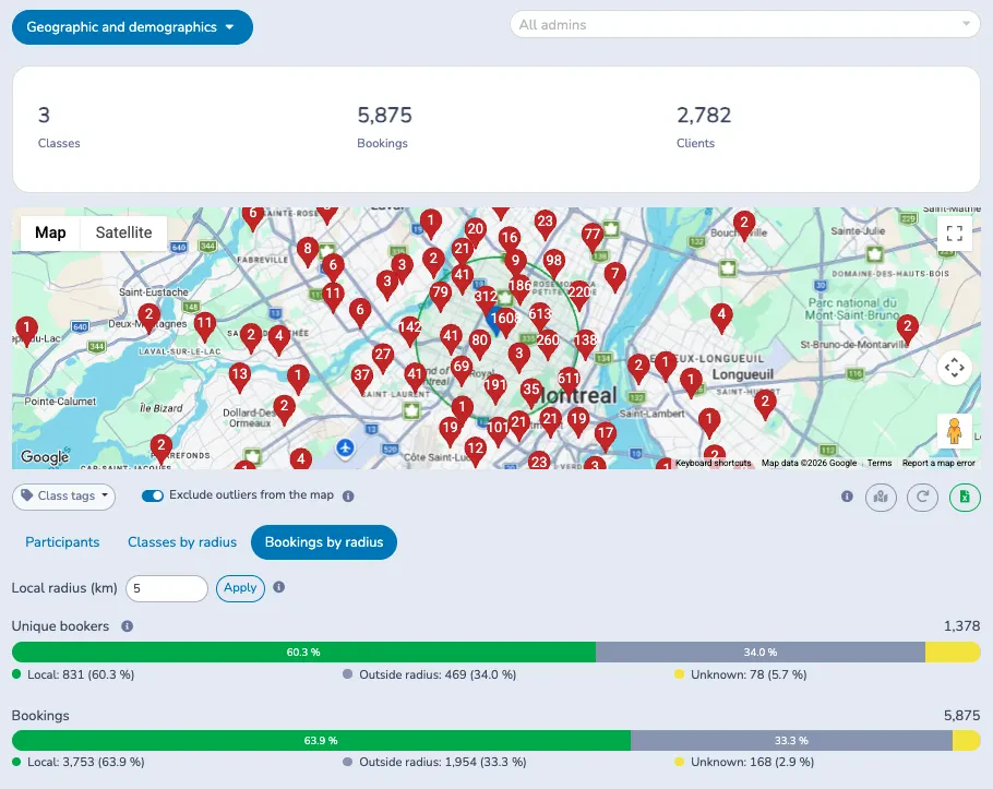
In this example, 831 of 1,378 unique bookers (60.3%) are local, while 3,753 of 5,875 bookings (63.9%) are local. Local clients account for a slightly larger share of booking activity than their share of unique bookers.
The Bookings by postal code table shows bookers, bookings, booking share, approximate distance and area. Both radius tables offer numbered pagination and Rows per page choices of 10, 25, 50 and 100.
Understand Unknown and estimated locations
Unknown remains in the percentage denominators. For example, a local percentage of 60% means 60% of the full population or activity total, including unknown locations, rather than 60% of only the located records.
Some Canadian postal codes use an estimated postal area while an exact postal-code location is unavailable. If the whole estimated area lies inside or outside the radius, it can be classified on that side. If the area may cross the boundary, it remains Unknown. The table identifies estimated areas and lookup states.
If the organization's address is missing or has not yet been located, all radius results remain Unknown. Postal-code lookups can also be pending or scheduled for another attempt. Use refresh after locations have been resolved; changing the radius does not fill in missing addresses.
The figures within each radius view use that view's population. Class participants, unique bookers and the combined Clients summary can have different totals.
Export or return to the same settings
Use the green Excel button in the toolbar to export the current report selection. The workbook includes the base report detail. From a radius view, it also includes the selected radius's area summary and postal-code detail for class registrations or bookings. Unknown locations stay in the radius export, and the map's outlier switch does not filter the workbook.
The report URL retains the selected dates, class tags, view, radius, outlier preference and table page-size settings. Copy the URL or use Saved reports to return to that configuration. Reopening it uses current data and still requires permission to access the report.